mercoledì 28 novembre 2018

Charstelenbach - Hufifirn


CHARSTELENBACH

HUFIFIRN

16 Novembre 2018

This a description of my last exploration.

Charstelenbach is the name of the river that is flowing from the glacier of Hufifirn.

First of all i should say that i have always been very lucky with my explorations, 90 - 95 % of them are good or very good canyons. With some luck, some fantasy, some good friends with the same passion, you can achieve some very satisfying discoveries in the outdoors.

Second i want to thank the first who went up this valley to have a look, and started the first exploration of a section of the upper canyon: Olivier Courtois (Mag), Timo and Gerald. 

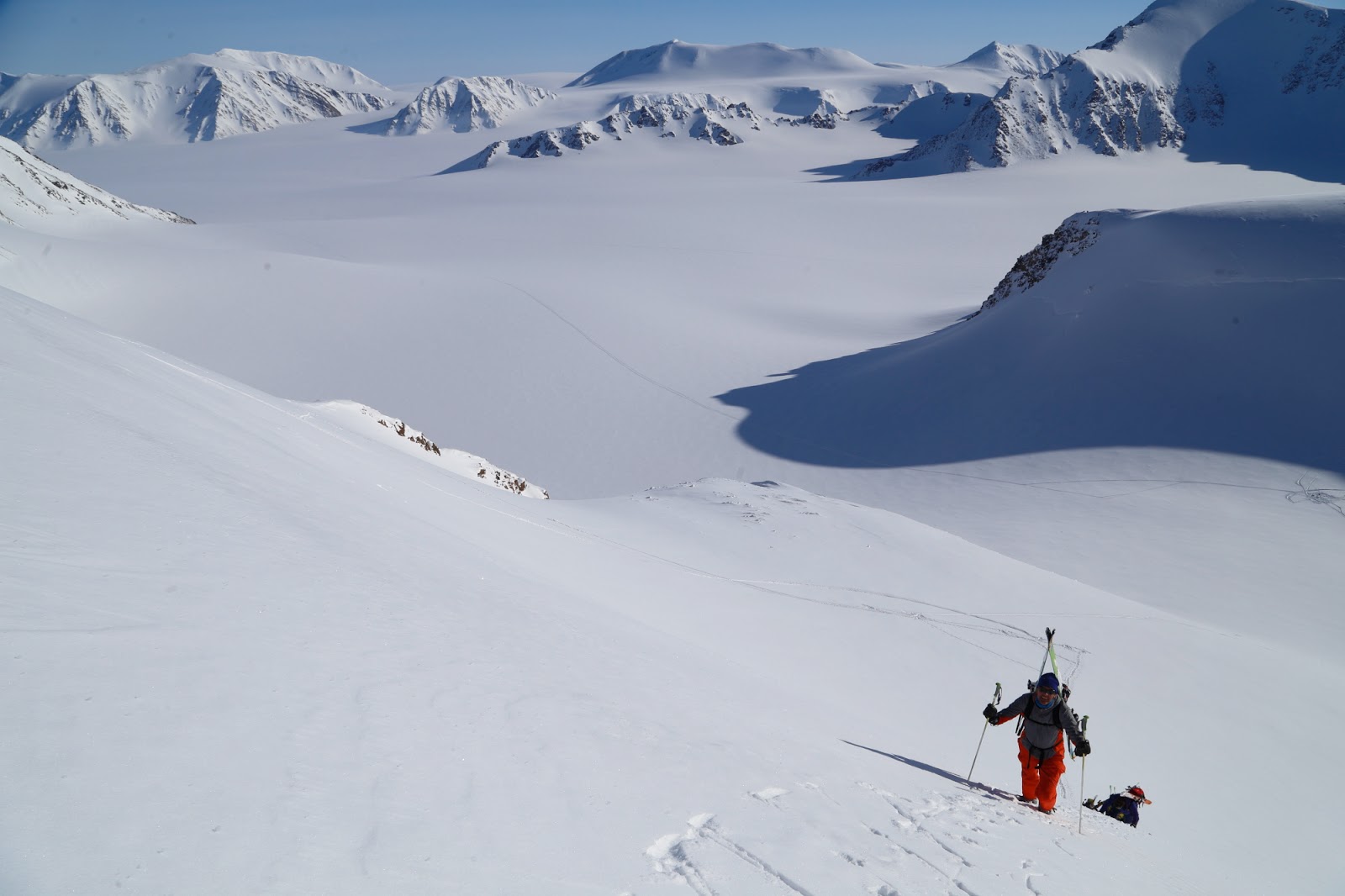
Probably the long walk to reach this valley has left it away from the eyes of any canyoneers except for some few determinate people.

I first visited the canyon, as it was already explored, the 11 of November. With a team of expert friends we did both the upper and the lower section after the lake. It was a long walk but we did not found too complex obstacles to reach the glacier, cross it, and then drop in the canyon already explored. Sure you need some real alpine experience. This part had 2 waterfalls equipped, really short, plus the possibility to climb up some small waterfalls under the snow patches stuck in the crack of the canyon. The lower section after the lake is also very scenic with 7 rappels and with a nice section in-between with some big springs falling from the sides of the canyon creating some fancy water curtains.


Long and steep walk-in, here Josito.


At the end i was not motivated at all to do again this trip, a very long day with a very little canyoning time in it.


High Alpine conditions: shade, cold, short days.

First snowfield near to the highest point of the approach.


During this day i had found an apparently possible access on the side of the glacier where i could see a stream flowing; nobody of the group absolutely wanted to have a deeper look or even thought to drop inside. I was the only "crazy" one in their point of view.


First view of the glacier before scrambling down


During the week i had contacts with some friends from Spain and also a caver-canyoneer from Slovenia: Andrej Hlis (i was always reading Hills like 95% of people...). The Spanish with Josito, Javi and Xavi are willing to do the Charstelenbach and other important canyons in swiss.

So somehow we agreed to meet at the bottom of the valley and we planned to have a try to the higher entrance on the glacier side. That was the only reason that motivated me to go up again. We prepared some ropes to left fixed, around 100 meters, in case it was not possible to go through.

On the approach walk i was not suffering too much but some friends where not expecting it to be so long ...and they had done the Segnes canyon the day before !

Anyway we reach the highest point near the Hufihutte, we scramble down to the glacier step on it, and we reach the big entrance hall i found few days ago.

On rappel to approach the glacier, Andrej

Javi

Xavi


While i wait for everybody i start to fix the first rope, Andrej arrives first and we take off the crampons to rappel down. The roof here is an amazing deep blue color arch, 15-20 meters high.


The passage between the big wall and the glacier, to reach the entrance hall


Andrej likes it !


We slowly drop into this wide tunnel but still the water is flowing on a slab in a very flat and open canyon shape.


First view down the tunnel


First rappel 


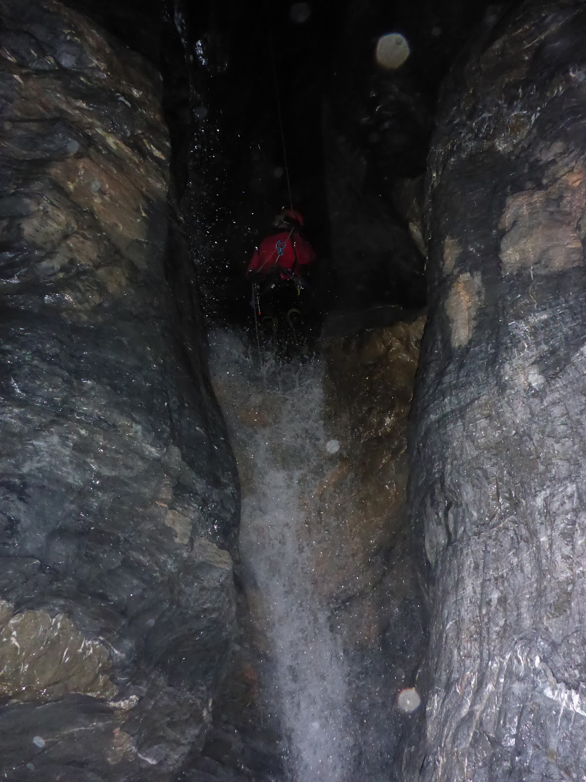
After around 80 meters, with an average inclination of 70°, the water makes a turn to the left and here we found the first pool and the beginning of the canyon. We could clearly see the configuration of a narrow canyon becoming deeper and deeper, with the ice staying blocked above us in-between the walls.


Andrej scouting


We decide to switch gear and suit up in canyoning configuration, to enter into the water and follow the canyon. We where already using the lamps to reach this point.

One intermediate anchor in the solid ice


Looking up the tunnel


In the dark we continue to rappel or climb down some small waterfalls, we are still leaving fixed ropes to have the option to climb back out.


In the first short rappels of the canyon
Large from 50 cm to 1-2 meters in average

At this point with little talking me and Andrej are feeling that it's quite "OK" to continue down, we don't have anymore ropes to leave behind. We only have our 3 long canyoning ropes to use. There is not much discussion or talking, we just go and each one is following the other one. I'm focused on putting the anchors and trying to anticipate any kind of problem, but i don't find any.


Looking up in the huge hall, 90 meters higher, a blue patch of ice closing the canyon top


We often look up. The canyon gets deeper and deeper, at a 25 meters waterfall we are 80-90 meters  under the glacier. Sometimes we can see a deep blue patch of ice, sometimes it's all black because the canyon is very narrow all the way. Only this section, after the 25 m fall, is 8 m wide and very high, like a cathedral, with also a big snow patch stuck between the walls.
We rarely see pieces of snow or ice that have fallen from the crack above, but nothing is granted down here, even if we are in a supposed "stable" period of the year.


The big snow patch suspended between the walls


An ice chockstone, typical from here....


My friend are looking at me with strange eyes, a lot of excitement, some fear, trying to take pictures and videos. Andrej has been in this canyon before, but entering further down, at the bottom of a 20 meter waterfall. He recognises it when we arrive there, some relief for us, we know we will get out from the canyon !


Beautiful rock white stripes

Two more small drops and we reach the part i visited 1 week ago, where the snow and ice are not anymore closing the top of the narrow canyon.


In the second half of the canyon


Always narrow canyon, we try to observe as much as possible


We all pop out of the canyon feeling intense and unforgettable emotions.


Exit from the canyon, last 2 rappels

I want to thank my friends for coming and believing in this exploration that is, as far as i know, the first in the world: a unique combination of alpinism, canyoning and speleology.

Many kind of caves have been explored inside the glaciers, but this is the first real canyon flowing under a glacier.
It's a unique formation. The glacier is flowing down the mountain ad reaches a constriction between two limestone mountains. The canyon is probably originated from a weaker section of rock and the water flow and the ice had carved this deep canyon under it. But the canyon is so narrow that the ice cannot flow inside it, only dropping pieces of ice, snow and some rocks in some seasons of the year.


Josito's drawing of the whole under-glacier canyon


The Team:
Josito Ysusrios, the best collection of extreme canyoning videos of the world
Xavi Guerrero, Spanish team organiser, master of Barranquistas.es
Javi Esquiruelo, mountain and canyon guide, with 3 mm socks...
Andrej Hlis, best canyoning photographer, caver and canyoneer
Pascal van Duin, mountain and canyon guide

A day in life to remember for ever !

Some more informations may be added later. 
This report is not a complete description of the whole trip. 
Many thing can change from what we found: the approach, the glacier, the canyon.

All pictures from Xavi, Josito and Pascal.
Drawing from Josito.


End of the day on the way down, back to normal life


I'm adding here some satellite photos in 3 different growing scales. The canyon is located at the bottom end of the glacier, not where you see the big waterfall, but it's the lowest stream on the picture, hidden by the shade. Very high flow during summer.


lunedì 5 novembre 2018

Svalbard Expedition 2019


SVALBARD

Viaggio SCIALPINISTICO nella regione di Atomfjella

Periodo 22 - 30 Aprile 

Sette giorni di tour nella zona più emozionante e interessante della parte settentrionale delle Spitsbergen. Atomfjella è un massiccio montuoso caratterizzato da centinaia di pendii scoscesi e da cime fantastiche, tra cui molte conosciute solo sulla cartina ma mai scalate. Siccome l' altezza di queste montagne è tra i 1400 e i 1700 metri, il dislivello di salita e' di circa 1000/1200 m. Il primo e l' ultimo giorno sono utilizzati per il trasferimento in motoslitta, un tragitto di circa 360 km a/r. Nei 6 giorni successivi saliremo qualche cima, tra cui il Perriertoppen (1717 m.) e scopriremo questo spettacolare labirinto di montagne. A mio parere uno dei posti più belli e poco frequentati nel mondo per fare scialpinismo.


 Per tutte le 7 notti si dorme nello stesso posto partendo per gite giornaliere e ritornando poi alla sera. Volendo si potrà anche cambiare il luogo del campo per raggiungere ulteriori cime in altre zone del massiccio montuoso degli Atomfjella. Bisogna essere allenati, essere bravi a sciare e preferibilmente avere già esperienza di scialpinismo invernale. 


Programma giorno per giorno:

1 giorno: trasporto dal luogo di pernottamento a Longyearbyen alla base di partenza. Informazioni sul tour, consegna dell' abbigliamento e istruzioni per la guida della motoslitta. Ultimi preparativi dei bagagli sulle slitte. Partiamo non appena siamo pronti e ci avviamo in direzione est attraversando la Adventdalen e la Sassendalen. In questa zona si incontrano spesso gruppi di renne. Nella tarda mattinata avvicinamento al Tempelfjorden e, prima di cominciarne la traversata su mare ghiacciato, ci fermiamo a Fredheim, l' antica stazione di caccia di Hilmar Nøis. Attraversiamo quindi il fiordo e percorriamo le valli e i ghiacciai della Bünsowland. In fondo alla valle di Gipsdalen mangiamo un piatto caldo. Si continua su per il Lomonosovfonna e si percorre il ghiacciaio in direzione nord. Dopo 50 chilometri passiamo vicini alle montagne della zona del Newtontoppen. Nel tardo pomeriggio si arriva al ghiacciaio del Gallerbreen, proprio nella zona degli Atomfjella. Scarichiamo i nostri bagagli dalle slitte e montiamo il campo con l'allarme anti-orso. Le motoslitte vengono riportate da chi ci ha accompagnato subito a Longyearbyen e torneranno a prenderci dopo 6 giorni. Cena in tendone riscaldato e pernottamento in tende con stufa.
2-6 giorno: colazione e preparativi dei tours. Le possibilità' di salite sono molte e varie, saliremo sulle vette più adatte a noi. Ci si porta dietro solo uno zaino leggero con lo stretto necessario per un tour in giornata e si pranza sempre con un piatto caldo durante il percorso. La scelta dei tours viene presa dai partecipanti insieme alla Guida, sulla base delle condizioni del tempo, della neve e dell'esperienza dei partecipanti. Una delle nostre vette preferite è il Perriertoppen (la cima più alta degli Atomfjella) oltre che tante altre cime sui 1400-1500 m. La zona è così ampia e varia che diverse settimane non basterebbero. Di sera si cena sempre in tendone riscaldato. C'è la possibilità di far asciugare i vestiti e le scarpe. Pernottamento in tende da 4-5 posti con stufetta. 


7 giorno: colazione e chiusura del campo. Si pranza all' aperto con un piatto caldo. Nel primo pomeriggio vengono a prenderci le motoslitte da Longyearbyen. Carichiamo le slitte e ci mettiamo in moto per il ritorno attraverso la Lomonosovfonna e la Bünsowland e la zona orientale di Nordenskiöldland. Si fa sosta lungo il percorso sia per riposarsi sia per far benzina. L' arrivo a Longyearbyen e' attorno alle ore 20. Riconsegna dell'attrezzatura e dell'abbigliamento da motoslitta. I partecipanti verranno accompagnati al loro luogo di pernottamento in citta'.


Incluso nel prezzo: pernottamenti in tende/jurte, assicurazione recupero di emergenza, equipaggiamento per il tour e per il campo, pensione completa, equipaggiamento di sicurezza, esperta Guida, trasporti come descritti da programma (motoslitta e macchina).
Non inclusi nel prezzo:, sacco a pelo invernale, viaggio aereo, pasti, cene e pernottamento a Longyearbyen, bibite, acqua minerale e assicurazione personale.

Costo a persona: € 4.500=
Il prezzo è soggetto a revisione in base al numero di partecipanti.

Info dirette: Pascal 0039 3355470126  - info@topcanyon.com

Avviso: questo itinerario si svolge in una regione remota al di sopra del circolo polare artico, si tratta di un viaggio molto esclusivo e di complessa realizzazione.


Link video: https://vimeo.com/287507793
Password: 888


SVALBARD


BACKCOUNTRY SKI in the region of Atomfjella

Period 22 - 30 April 


This is a seven day trip in to the most exciting area of the north part of Spitsbergen. The Atomfjella is an area with mountains with hundreds of steep mountainsides and fabulous peaks. Most of them known only from the maps, not yet climbed. Since all mountains in this area are from 1400 to 1700 meters high most routes on this trip will have a differences in altitude, around 1000 meters. The first and last day of the trip will be spend on transportation by snowmobile to and from Longyearbyen, approximately 180 kilometres one way. The rest of the time, six days, we will spend exploring this spectacular mountain area, climbing some of the peaks; among them mount Perrier (1717 meters over sea level). We will have a base camp for all the seven nights we spend in big warmed tent, and every day we will do daytrips starting off from the base camp. If we wish we can move the camp to reach more peaks more easily. To participate in this trip you have to be in very good physical condition, as well as a good skier and you should be experienced in outdoor winter activities. In my opinion one of the most fantastic country on the planet to do backcountry ski with nobody else around. 


Day by day program:

Day 1: pick up at your hotel in Longyearbyen. Briefing about the trip and transportation by snowmobile, last preparations and packing of snowmobiles and sledges before dressing up for the snowmobile trip. We start as soon as we are ready, and drive eastwards, through Adventdalen and Sassendalen. If we are lucky we will spot Svalbard Reindeer in this area, late afternoon we will reach Tempelfjord and before crossing the fjord ice we will make a stop at Fredheim, an old trapper’s station. After crossing the fjord we will drive through valleys and glaciers over to Bünsowland. We will have a warm lunch in the bottom of Gipsdalen before driving up Lomonosovfonna and drive north over the glacier. After app. 50 kilometres we will se the Newton area, and we will eventually stop by Gallerbreen, in the Atomfjella area. Here we unpack the snowmobiles and set our first camp. The snowmobiles will return to Longyearbyen the same day, and then pick us up again after 6 days. Dinner in a big warmed tent and sleeping in tents 4-5 places with stove.

Day 2- day 6: breakfast and preparations for the trips. We will choose witch peaks to climb from an enormous and varied choice in the area. We will pack our small rucksacks for the day, and we always bring warm lunch. The routes will be decided by the participants and the guide together, depending on weather and snow conditions as well as the participants’ condition. On this trip we usually climb the top of mount Perrier (the highest in Atomfjella) and many other mountains around 1400-1500 meters. At night we will have dinner in the basecamp in a big warmed tent, and it is possible to dry clothes and shoes. 
We spend the night in large warmed tents.

Day 7: Breakfast and clearing the camp area. We will have a warm lunch outdoors and early afternoon the snowmobiles will arrive from Longyearbyen to pick us up. We dress up for driving, pack our things on the sledges and start the ride back to Longyearbyen. We will make breaks on the way. Estimated arrival back in Longyearbyen is 20.00. After unpacking the sledges we will bring you to your hotel in Longyearbyen.


Included in the price: overnights in tent/jurts with stove, rescue insurance, camping equipment, full board, experienced Guide, emergency/safety equipment, transportation as described in program (by snowmobile, car).
Not included in the price: warm sleeping bag, flights, meals and overnight in Longyearbyen, beverages, mineral water, personal travel insurance.

Price per person: € 4.500,00=

The price is subject to some adaptation depending on the number of participants.

Direct informations Pascal 0039 3355470126 - info@topcanyon.com

Warning: this trip is taking place in a remote region above the arctic polar circle, complex to organise and very exclusive.

link to video: https://vimeo.com/287507793
password: 888


sabato 17 dicembre 2016

Trummelbach IV - The connection


TRUMMELBACH IV

THE CONNECTION IS DONE  14-12-2016  !!


Holzi the organiser, Franz Baumgartner, Sven Scharer and Pascal van Duin

have done this connection section of Trummelbach between TR 3 and TR 5 "the classic".

It's not the "Las Puerta del Infierno" as our Spanish friends like to call the swiss cold technical canyons.


It's a canyon not too complicated in the conditions we found, only big problem is the risk of rock and ice falling from above, almost everywhere, but mostly under the serac of the Giesengletcher; you have above your head big and steep mountains, rock walls up to 2.400 meters high, so everything can naturally fall down thanks to the gravity force.


The canyon is deep in his best sections; it is big everywhere and the view above is always too big for small men like us; the light is little down there, even in a perfect sunshine day you feel like it's a cloudy day.


Holzi wrote that now it's one of the highest, or the highest elevation for a canyon in Europe, if you connect all the valley from TR 1 to TR 5 : 


Total Altitude difference 1855 m / distance 6.4km


On the approach we used the exit ropes of Trummelbach 3, not much snow but ice yes !

First rappel

Immediately beautiful

Very icy here, there is an icefall above so all the water coming down is freezing all around

A bit slippery


Tricky move to avoid the bath...

Partly iced and partly clean

Many good sights

And some swimmers too !

Top slot here ! 28 meters for the 2 highest drops of this section.

Exiting the first big narrow section

We reach the big snow-icefield deposit

We go under a first short section

One rappel to set

Now another 100 meters under the ice tunnel, very nice

At the exit something has collapsed

After the snowfield 

Some walking sections under huge walls of more than 2.000 meters

Slides and jumps

Drilling for the next fall, again a nice canyon

Holzi first

Sven following

Some more falls

I climbed up here to disengage a stuck rope and took pictures

Nice panorama here, we are small

We reach another section, a real beauty

Dropping in

A view from the other side of the same drop

Smiling in this nice toboggan

Lovely fall

Some short swims
The wood bridge at the end of our exploration

Arriving at the bridge, the end. Getting here from this side is a special feeling as usually we started here to enter the Trummelbach classic section that is now known as "5" of this long valley.